
Accessibility Mapper
AccessibilityMapper is a native macOS and Windows application for advocates, planners, and community organizers who need to quickly visualize non-car mobility coverage on a map.
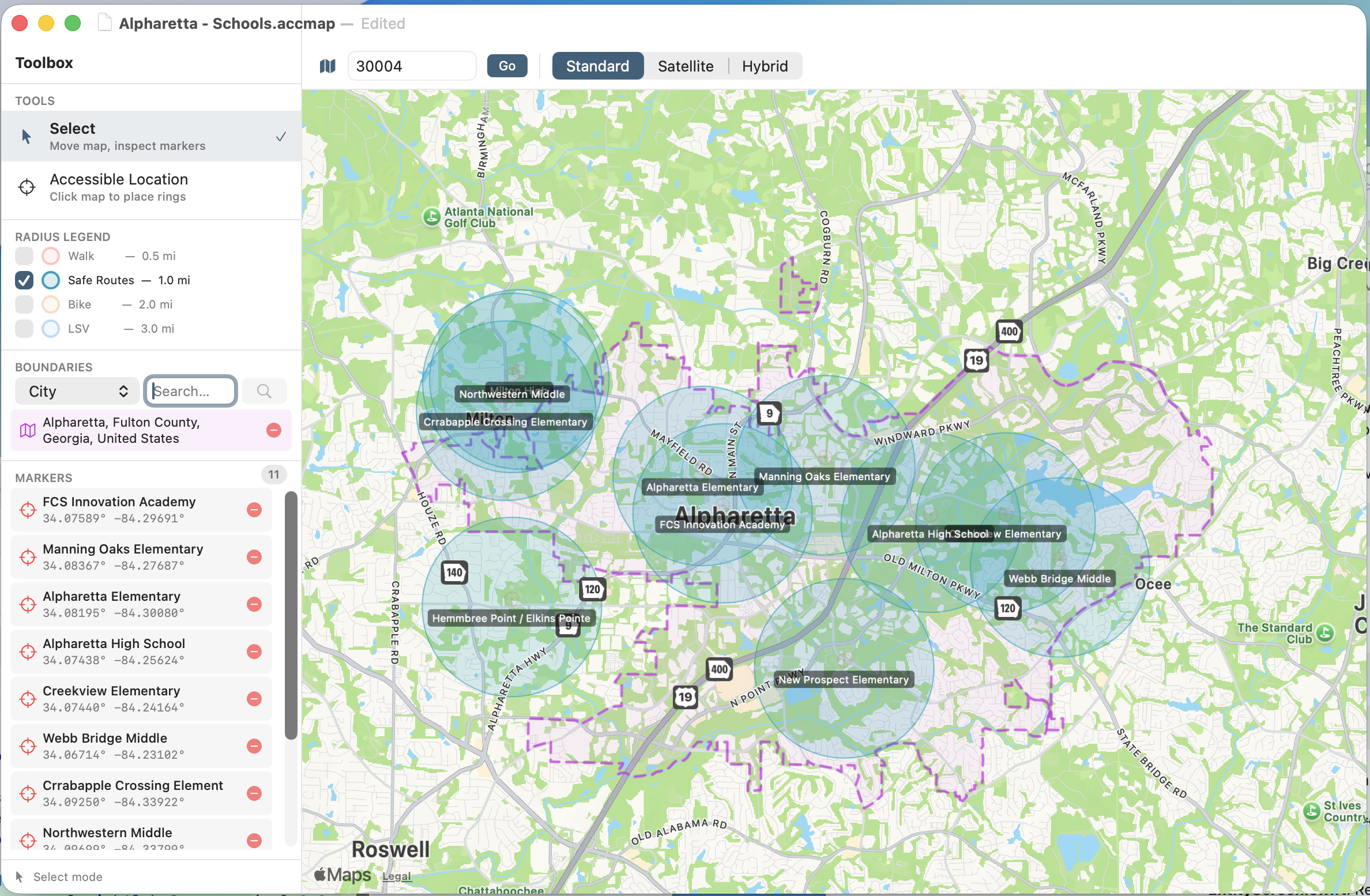
Drop a marker on any location and four concentric bullseye rings appear instantly — a red 0.5-mile walking zone, a teal 1.0-mile Safe Routes to School ring, an orange 2.0-mile cycling zone, and a blue 3.0-mile low-speed vehicle corridor covering e-bikes, scooters, and similar modes. Multiple markers can be placed, named, and toggled independently, giving audiences an immediate picture of where people can move without a car.
Additional tools include on-demand city, county, and state boundary overlays, three map styles (standard, satellite, hybrid), and individual layer toggles for each ring type. Maps are saved as portable .accmap files that preserve all markers, boundaries, and viewport settings.
AccessibilityMapper is available on the Mac App Store and as a direct download from druware.com. The source code is open under the GNU General Public License v3; compiled binaries are covered by a commercial license. Free for personal use — if it saves you time, consider supporting it through the a donation on the Druware website.
Visualize non-car mobility. Advocate with clarity.
The Problem It Solves
Advocacy work around sidewalks, bike lanes, and multi-use paths demands clear visuals. Traditional mapping tools are slow, tedious, and require GIS expertise. AccessibilityMapper lets you drop a marker on any location and instantly see four meaningful distance zones radiating outward — giving any audience an immediate, intuitive picture of where people can safely move without a car.
How It Works
Place one or more Accessible Location markers anywhere on the map. Each marker automatically renders four concentric bullseye rings, each representing a standard mobility threshold:
| Ring | Color | Radius | Represents |
|---|---|---|---|
| Walk | Red | 0.5 miles | Comfortable walking distance |
| Safe Routes | Teal | 1.0 miles | Safe Routes to School standard |
| Bike | Orange | 2.0 miles | Practical cycling distance |
| LSV | Blue | 3.0 miles | Low-speed vehicle zone (e-bikes, scooters, one-wheels, golf carts) |
When a marker is selected, its rings are visually emphasized so it stands out from the rest of the map. Double-click any marker in the list to fly the map to that location.
Key Features
Document-Based Workflow
Maps are saved as .accmap files — a clean JSON format that stores your viewport, markers, and any boundary overlays. Open multiple maps side-by-side, share files with collaborators, or archive maps for future reference.
Boundary Overlays
Fetch city, county/parish, or state boundary polygons on demand and overlay them directly on your map. Boundaries render as a distinctive purple hatched polygon so they remain readable over any map style. Remove individual boundaries at any time from the toolbox.
Map Styles
Switch between standard, satellite, and hybrid map types to match your presentation context — street-level detail for planning meetings, satellite for community outreach, hybrid for the best of both.
Layer Toggles
Each of the four ring types can be independently shown or hidden. Focus on just the walking zone for a sidewalk gap analysis, or show all four layers to communicate the full spectrum of mobility options.
Marker Management
- Name markers inline — labels appear as pill overlays directly on the map
- Select markers from the toolbox list or by clicking the map pin
- Delete markers from the callout popup or the toolbox list
- Marker count shown at a glance in the toolbox header
Location Search
Navigate to any area by searching for a zip code, city, or city and state. The map flies smoothly to the matched region so you can start placing markers immediately.
Who It's For
- Advocates presenting the case for sidewalk or bike lane investment to city councils and planning boards
- Safe Routes to School coordinators mapping coverage gaps around schools
- Urban planners and consultants producing quick visual analyses for community meetings
- Non-profit organizations creating materials that show mobility equity in underserved neighborhoods
Platform & Availability
AccessibilityMapper is a native application, using SwiftUI and MapKit on Apple platforms and c#.net on Windows.
| Channel | Details |
|---|---|
| Mac App Store | Available — supports personal and commercial use |
| Direct download | Available at druware.com |
| Source code | Open source on GitHub under the GNU General Public License v3 |
The source code is free for personal use and open to all under the GPL v3. Commercial binary distribution is available through the App Store and druware.com under a separate commercial license.
File Format
Maps are stored as human-readable .accmap files (JSON). Each file contains:
- Viewport center coordinates and zoom level
- Map type preference (standard / satellite / hybrid)
- All marker positions and labels
- Any boundary overlays loaded during the session
Files are portable, version-controlled friendly, and can be opened by any JSON viewer for inspection or programmatic use.
Copyright & License
Copyright © 2026 Druware Software Development. All rights reserved.
Source code is licensed under the GNU General Public License v3. Compiled binaries distributed through the Mac App Store and druware.com are covered by the Druware Commercial License. See LICENSE and LICENSE-COMMERCIAL in the project root for full terms.
Created by Andrew Satori.